Downloaded 48 times

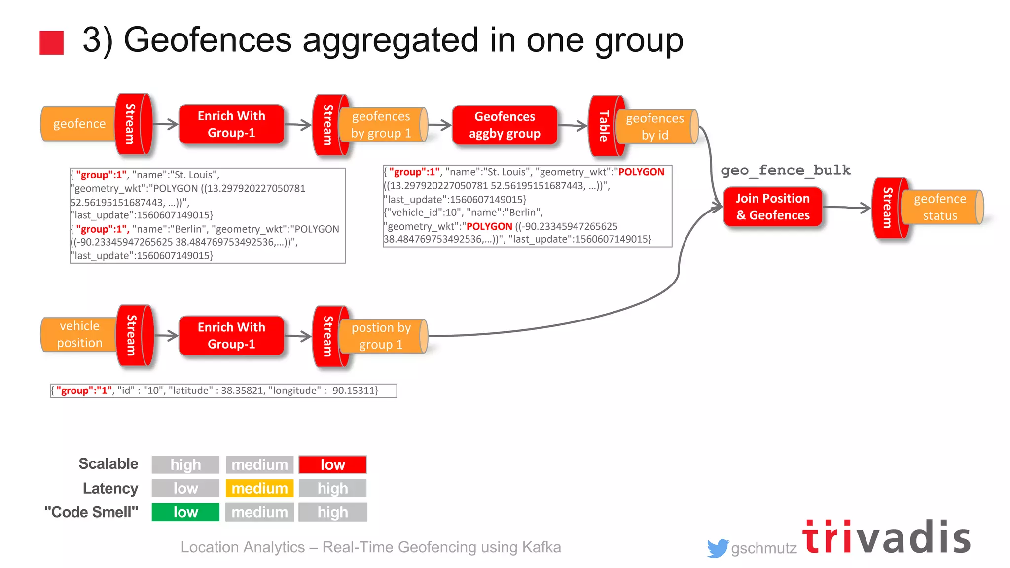
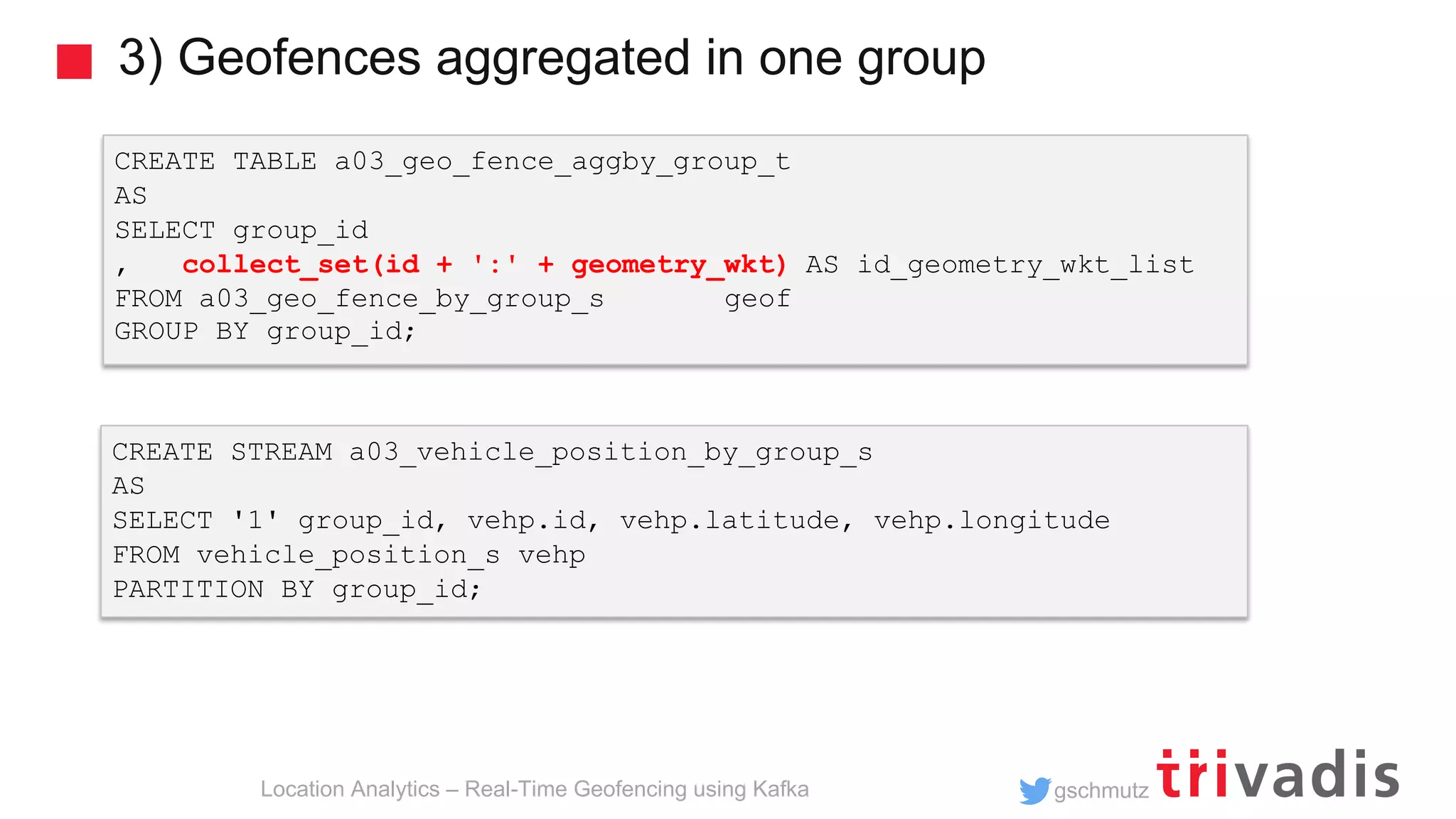
![gschmutz 3) Geofences aggregated in one group Location Analytics – Real-Time Geofencing using Kafka ksql> SELECT * FROM a03_geo_fence_status_s; 46 | 52.47546 | 13.34851 | [1:OUTSIDE, 3:INSIDE] 46 | 52.47521 | 13.34881 | [1:OUTSIDE, 3:INSIDE] ... CREATE STREAM a03_geo_fence_status_s AS SELECT vehp.id, vehp.latitude, vehp.longitude, geo_fence_bulk(vehp.latitude, vehp.longitude, geofaggid_geometry_wkt_list) AS geofence_status FROM a03_vehicle_position_by_group_s vehp LEFT JOIN a03_geo_fence_aggby_group_t geofagg ON vehp.group_id = geofagg.group_id; As many as there are geo-fences](https://image.slidesharecdn.com/geo-analytics-with-kafka-v1-190617155739/75/Location-Analytics-Real-Time-Geofencing-using-Apache-Kafka-19-2048.jpg)
![gschmutz Geo Hash Custom UDF Location Analytics – Real-Time Geofencing using Kafka ksql> SELECT latitude, longitude, geo_hash(latitude, longitude, 3) >FROM test_geo_udf_s; 38.484769753492536 | -90.23345947265625 | 9yz public String geohash(final double latitude, final double longitude, int length) public List<String> neighbours(String geohash) public String adjacentHash(String geohash, String directionString) public List<String> coverBoundingBox(String geometryWKT, int length) ksql> SELECT geometry_wkt, geo_hash(geometry_wkt, 5) >FROM test_geo_udf_s; POLYGON ((-90.23345947265625 38.484769753492536, -90.25886535644531 38.47455675836861, ...)) | [9yzf6, 9yzf7, 9yzfd, 9yzfe, 9yzff, 9yzfg, 9yzfk, 9yzfs, 9yzfu]](https://image.slidesharecdn.com/geo-analytics-with-kafka-v1-190617155739/75/Location-Analytics-Real-Time-Geofencing-using-Apache-Kafka-21-2048.jpg)
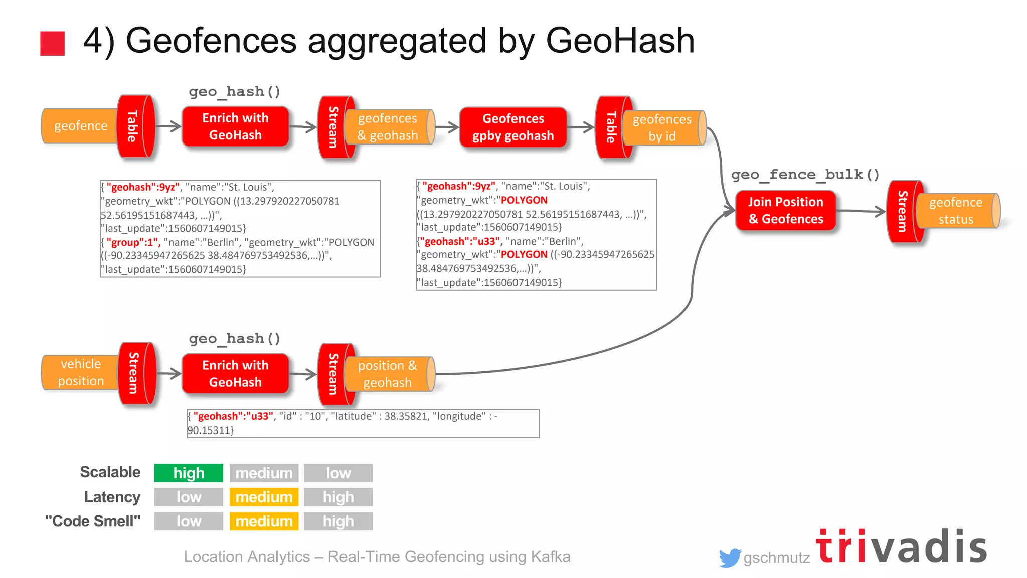
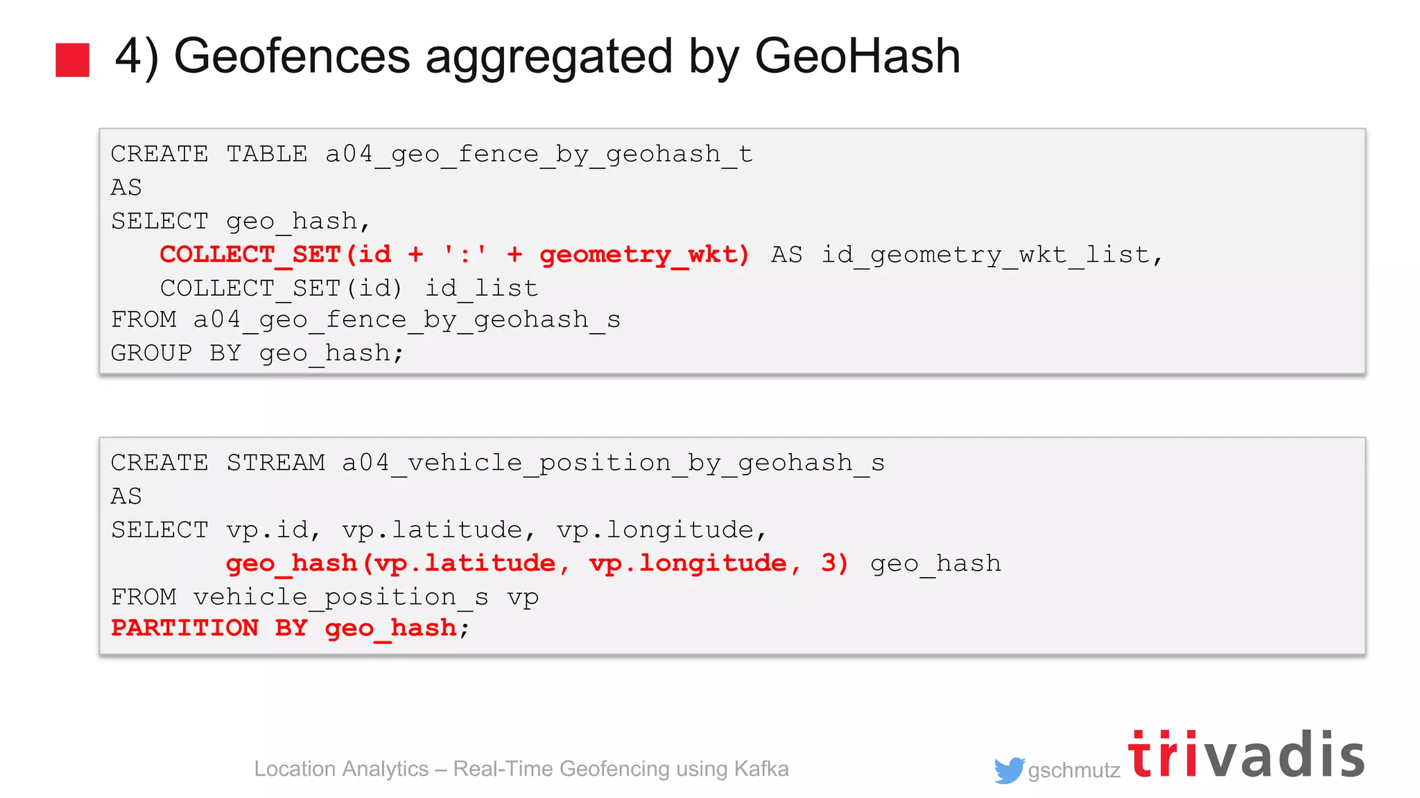
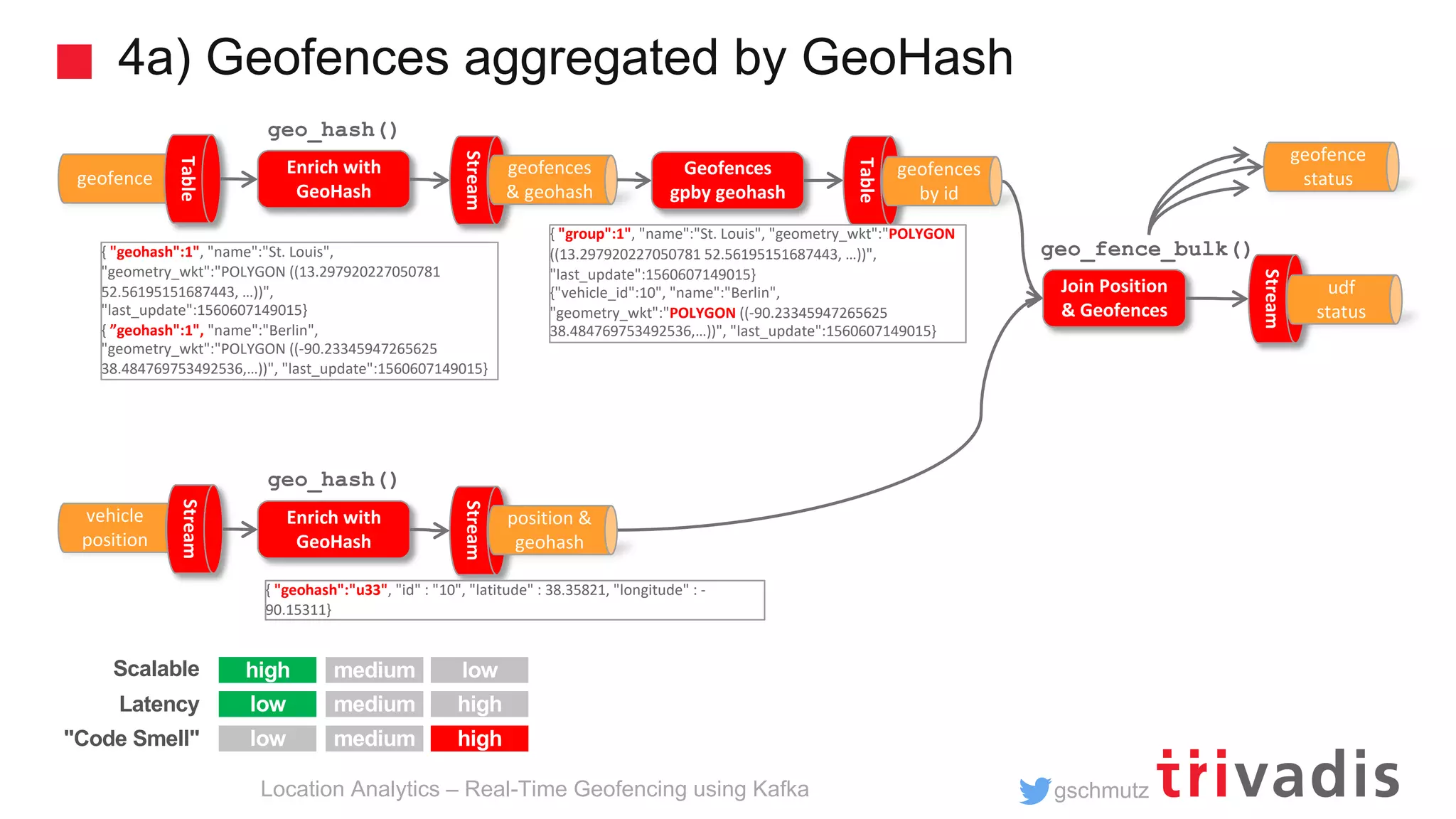
![gschmutz 4) Geofences aggregated by GeoHash Location Analytics – Real-Time Geofencing using Kafka CREATE STREAM a04_geo_fence_by_geohash_s AS SELECT geo_hash(geometry_wkt, 3)[0] geo_hash, id, name, geometry_wkt FROM a04_geo_fence_s PARTITION by geo_hash; INSERT INTO a04_geo_fence_by_geohash_s SELECT geo_hash(geometry_wkt, 3)[1] geo_hash, id, name, geometry_wkt FROM a04_geo_fence_s WHERE geo_hash(geometry_wkt, 3)[1] IS NOT NULL PARTITION BY geo_hash;s INSERT INTO a04_geo_fence_by_geohash_s SELECT ... There is no explode() functionality in KSQL! https://github.com/confluentinc/ksql/issues/527](https://image.slidesharecdn.com/geo-analytics-with-kafka-v1-190617155739/75/Location-Analytics-Real-Time-Geofencing-using-Apache-Kafka-23-2048.jpg)
![gschmutz 4) Geofences aggregated by GeoHash Location Analytics – Real-Time Geofencing using Kafka CREATE STREAM a04_geo_fence_status_s AS SELECT vp.geo_hash, vp.id, vp.latitude, vp.longitude, geo_fence_bulk (vp.latitude, vp.longitude, gf.id_geometry_wkt_list) AS fence_status FROM a04_vehicle_position_by_geohash_s vp LEFT JOIN a04_geo_fence_by_geohash_t gf ON (vp.geo_hash = gf.geo_hash); ksql> SELECT * FROM a04_geo_fence_status_s; u33 | 46 | 52.3906 | 13.1599 | [3:OUTSIDE] u33 | 46 | 52.3906 | 13.1599 | [3:OUTSIDE] 9yz | 12 | 38.34409 | -90.15034 | [2:OUTSIDE, 1:OUTSIDE] ... As many as there are geo-fences in geohash](https://image.slidesharecdn.com/geo-analytics-with-kafka-v1-190617155739/75/Location-Analytics-Real-Time-Geofencing-using-Apache-Kafka-25-2048.jpg)
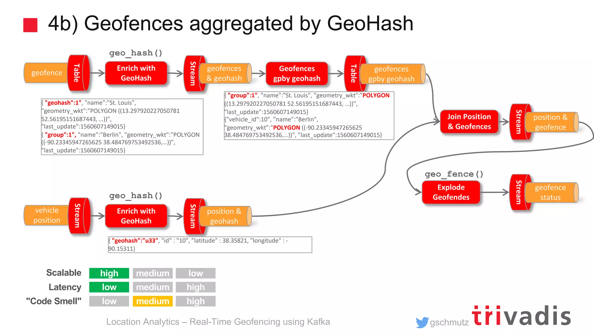
![gschmutz 4b) Geofences aggregated by GeoHash Location Analytics – Real-Time Geofencing using Kafka CREATE STREAM a04b_geofence_udf_status_s AS SELECT id, latitude, longitude, id_list[0] AS geofence_id, geo_fence(latitude, longitude, geometry_wkt_list[0]) AS geofence_status FROM a04_vehicle_position_by_geohash_s vp LEFT JOIN a04_geo_fence_by_geohash_t gf ON (vp.geo_hash = gf.geo_hash); INSERT INTO a04b_geofence_udf_status_s SELECT id, latitude, longitude, id_list[1] geofence_id, geo_fence(latitude, longitude, geometry_wkt_list[1]) AS geofence_status FROM a04_vehicle_position_by_geohash_s vp LEFT JOIN a04_geo_fence_by_geohash_t gf ON (vp.geo_hash = gf.geo_hash) WHERE id_list[1] IS NOT NULL;](https://image.slidesharecdn.com/geo-analytics-with-kafka-v1-190617155739/75/Location-Analytics-Real-Time-Geofencing-using-Apache-Kafka-28-2048.jpg)
![gschmutz Tile38 – How does it work? Location Analytics – Real-Time Geofencing using Kafka > SETCHAN berlin WITHIN vehicle FENCE OBJECT {"type":"Polygon","coordinates":[[[13.297920227050781,52.56195151687443],[1 3.2440185546875,52.530216577830124],[13.267364501953125,52.45998421679598], [13.35113525390625,52.44826791583386],[13.405036926269531,52.44952338289473 ],[13.501167297363281,52.47148826410652], ...]]} > SUBSCRIBE berlin {"ok":true,"command":"subscribe","channel":"berlin","num":1,"elapsed":"5.85 µs"} . . . {"command":"set","group":"5d07581689807d000193ac33","detect":"outside","hoo k":"berlin","key":"vehicle","time":"2019-06- 17T09:06:30.624923584Z","id":"10","object":{"type":"Point","coordinates":[1 3.3096,52.4497]}} SET vehicle 10 POINT 52.4497 13.3096](https://image.slidesharecdn.com/geo-analytics-with-kafka-v1-190617155739/75/Location-Analytics-Real-Time-Geofencing-using-Apache-Kafka-31-2048.jpg)
![gschmutz Tile38 – How does it work? Location Analytics – Real-Time Geofencing using Kafka > SETHOOK berlin_hook kafka://broker-1:9092/tile38_geofence_status WITHIN vehicle FENCE OBJECT {"type":"Polygon","coordinates":[[[13.297920227050781,52.56195151687443],[1 3.2440185546875,52.530216577830124],[13.267364501953125,52.45998421679598], [13.35113525390625,52.44826791583386],[13.405036926269531,52.44952338289473 ],[13.501167297363281,52.47148826410652], ...]]} bigdata@bigdata:~$ kafkacat -b localhost -t tile38_geofence_status % Auto-selecting Consumer mode (use -P or -C to override) {"command":"set","group":"5d07581689807d000193ac34","detect":"outside","hoo k":"berlin_hook","key":"vehicle","time":"2019-06- 17T09:12:00.488599119Z","id":"10","object":{"type":"Point","coordinates":[1 3.3096,52.4497]}} SET vehicle 10 POINT 52.4497 13.3096](https://image.slidesharecdn.com/geo-analytics-with-kafka-v1-190617155739/75/Location-Analytics-Real-Time-Geofencing-using-Apache-Kafka-32-2048.jpg)
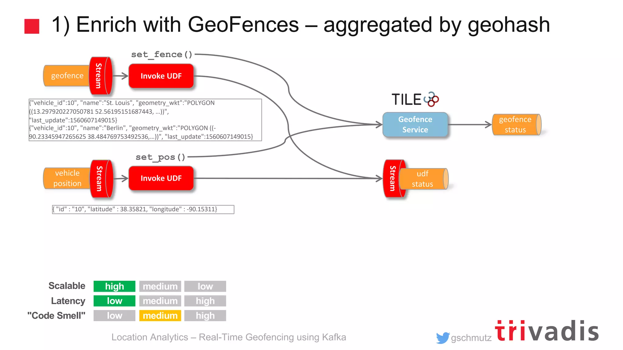
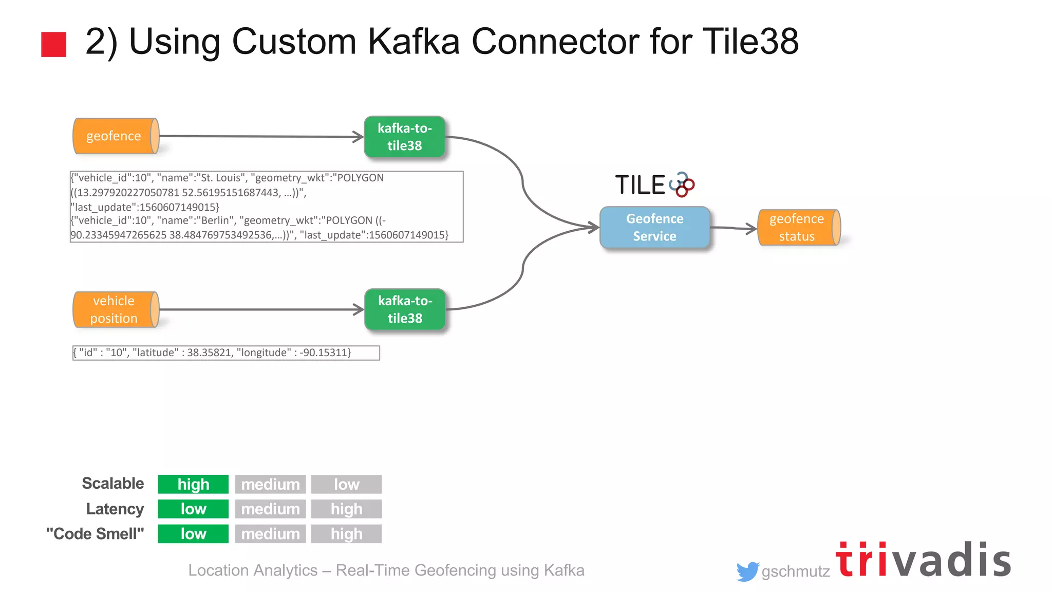
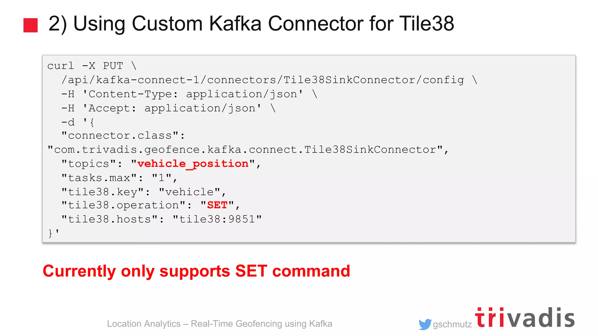
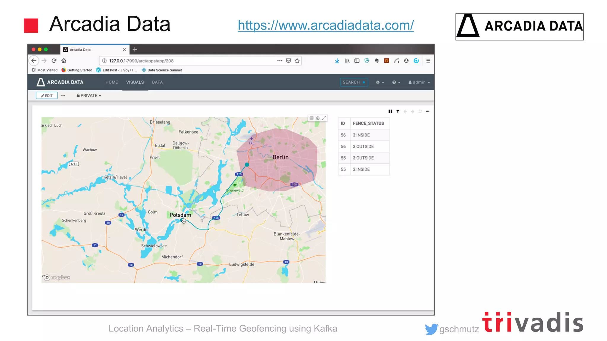


This document discusses implementing real-time geofencing using Apache Kafka. It presents 4 approaches to join vehicle position data with geofence polygons: 1) using a cross join, 2) aggregating geofences by group, 3) using a custom UDF to aggregate geofences by geohash, and 4) aggregating geofences into a table grouped by geohash to improve performance. The document focuses on implementing these approaches using KSQL to perform stream processing on the vehicle position and geofence data streams with SQL-like queries.