The document presents a new connectivity-based localization method using the centroid of a triangle for wireless sensor networks (WSNs), aiming to improve localization accuracy while minimizing error. Simulation results indicate that this modified centroid method (centroid_t) performs better than existing centroid methods, particularly as the number of anchor nodes and radio range increases. The study highlights the balance between accuracy, cost, and energy consumption in localization methods for WSN applications.
![www.ijemr.net ISSN (ONLINE): 2250-0758, ISSN (PRINT): 2394-6962 131 Copyright © 2018. IJEMR. All Rights Reserved. Volume-8, Issue-5, October 2018 International Journal of Engineering and Management Research Page Number: 131-136 DOI: doi.org/10.31033/ijemr.8.5.14 Minimization of Localization Error using Connectivity based Geometrical Method in Wireless Sensor Networks Sita Kumari. CH1 and Dr. S.P. Setty2 1 Assistant Professor, Department of Information Technology, Gayatri Vidya Parishad College of Engineering(A), INDIA 2 Professor, Department of Computer Science and Systems Engineering, Andhrauniversity College of Engineering, INDIA 1 Corresponding Author: sitha_kumari@gvpce.ac.in ABSTRACT Many localization schemes are designed for finding the geographical coordinates of the unlocalized node in the network. Still, it is a difficult problem to find accurate and efficient localization schemes in the Wireless Sensor Networks (WSNs). We proposed a new method, connectivity based WSN node localization using one of the geometrical method namely centroid of a triangle. By developing the centroid of a triangle from the WSN network model in terms of localization requirements. The simulation outcomes have shown that the modified centroid (centroid_T) performs marginally better than the existing centroid method with a marginally increase in the computation process. We also observe the variation of localization error with various anchor nodes, radio range, and network size. Keywords— Centroid of a Triangle, Localization, WSN I. INTRODUCTION Wireless Sensor Network (WSN) is a wireless intelligent network. It has ten to thousand sensor nodes. These nodes are communicating through radio waves and infrared medium. Each sensor node integration of a sensing device, a processing circuit, a communication unit, a power source, and required software[1][2]. The sensing device is the combination of sensors and ADC. The sensors are gathering the raw information externally and fed to the ADC. The ADC provides the corresponding information and interacts with the processing unit. The processing circuit performing computations according to the requirements given by software instructions. The results are stored into memory or transferred to another sensor node through the communication unit. The communication unit is the combination of transmitter and receiver, it transmitting and receiving the data among the sensor nodes. Finally, power source generates the power for processing and transmission of data to among the nodes. In WSNs, many of the applications such as target detection [3][4], forest fire detection, monitoring of the environment[5], traffic monitoring[5], hospital management[6], and industrial applications[5] require the position of the data that is localization, because the data received from any sensor nodes remain meaningless until it correlated with information about the position. Localization is the process of finding the physical coordinates of the sensor nodes with the help of known reference nodes or Global Positioning System (GPS). Basically, sensor nodes have limited computational power, radio communication range, and battery lifetime, there is a need for efficient and reliable localization methods. Localization is an interesting and important research area, many authors are proposed many localization algorithms, still, it requires accurate and minimum power with low-cost localization methods. When the developer design localization methods, they should consider following properties [7]. i. The developer must consider minimum power and cost of hardware because basically, WSN nodes are low power, low communication coverage area. ii. The localization is suitable in three dimensional(3D) node deployment models. iii. The Global Positioning System(GPS) is not suitable for in all environments because signal problems and it needs more hardware. If ever sensor node has GPS it requires more hardware, then cost and power consumption increase. iv. Node density is also an important factor when localization methods are implemented because more reference nodes (Anchor nodes)](https://image.slidesharecdn.com/paper19-190918102527/75/Minimization-of-Localization-Error-using-Connectivity-based-Geometrical-Method-in-Wireless-Sensor-Networks-1-2048.jpg)
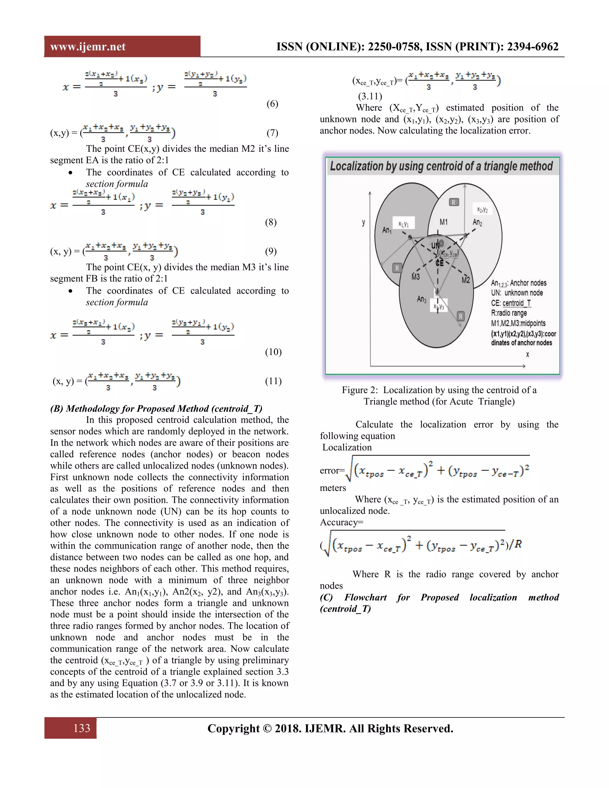
![www.ijemr.net ISSN (ONLINE): 2250-0758, ISSN (PRINT): 2394-6962 132 Copyright © 2018. IJEMR. All Rights Reserved. provide better accuracy but energy consumption is also increasing, So optimum number of anchors are required. v. The designed localization algorithms should be universal, not for particular applications it should applicable indoor as well as outdoor localization applications Localization methods have classified according to different criteria such as mode of operations, measurement and calculations, importance of accuracy, hardware complexity, network architecture, and node deployment models. According to measurement and classifications, the localization methods have divided into range-based and range-free methods. In the range-based localization method, the position of unlocalized nodes can be estimated with the help of distance or time difference or angle or signal strenth between the unknown node and reference nodes. Examples of range based methods[8] are TDOA, TOA, AOA, RSSI. In range-free methods the position is calculated, connectivity between reference nodes in terms of hop count only no need of distance between reference nodes. The well-known methods for range-free localization[9] are Centroid, Weighted centroid, DV-hop, Improved DV-hop, APIT, Bounding box, Amorphous, II. RELATED WORK The centroid is a simple range-free localization scheme introduced by Bulusu et al., [10]. Centroid uses a regular mesh topology of nodes which are known their positions and serve as reference points or anchors. These anchors send their location information as an announcement called beacons in periodically. The beacon consists of a reference location and connectivity metric based on received packets are used to rate the connectivity between an unknown node and its available reference locations. In equation 1 NoBrecv and NoBsend denote the number of beacons received from and sent by the ith anchor node in a time period t. If the receiving node receives the beacons grater than the threshold value in period t, then the nodes are considered with in a radio range. (1) Where CM is connectivity metric NoBrecv(i,t) is Number of Beacons received i th anchor in time period ‘t’ NoBsend(i,t) is Number of Beacons send i th anchor in time period ‘t’ Those anchors connectivity count CMi > CMthresh are considered for localization. The authors propose to set CMthresh = 90, i.e., only anchors with high delivery ratios are assumed to be connected to the unknown node. The set of ‘m’ anchors chosen reference points are used to estimate the location of the unlocalized node by using given Equation (2) (xest,yest)=( (2) Where (Xest, Yest) estimation position of the unlocalised node, (x1,y1), (x2,y2), ….( xm, ym) locations of ‘m’anchors. III. METHODOLOGY (A) Localization by using the centroid of a triangle (centroid_T) Preliminary concepts for proposed method Where the three medians intersect in a triangle is called centroid[11]. Let ABC be a triangle and their coordinates are A(x1,y1), B(x2,y2), and C(x3,y3). D, E, and F are the mid points and M1, M2, and M3 are the medians of a triangle. Figure 1: Calculation of centroid of a Triangle The centroid CE(x, y) derived as follows D is the mid-point of line segment AB of a triangle and the coordinates of D can be determined using mid-point formula ( (3) E is the mid-point of line segment BC of a triangle and the coordinates of E can be determined using mid-point formula • ( (4) F is the mid-point of line segment CA of a triangle and the coordinates of F can be determined using mid-point formula • ( (5) The point CE (x,y) divides the median M1 it’s line segment DC is the ratio of 2:1 • The coordinates of CE calculated according to section formula (x,y)](https://image.slidesharecdn.com/paper19-190918102527/75/Minimization-of-Localization-Error-using-Connectivity-based-Geometrical-Method-in-Wireless-Sensor-Networks-2-2048.jpg)
![www.ijemr.net ISSN (ONLINE): 2250-0758, ISSN (PRINT): 2394-6962 136 Copyright © 2018. IJEMR. All Rights Reserved. REFERENCES [1] Hu. F, Cao. X. (2010). Wireless sensor networks: Principles and practice. (1st ed.). CRC Press: Taylor & Francis Group. [2] Waltenegus Da, & Christian. P. (2010). Fundamentals of wireless sensor networks: Theory and practice. Wiley Publications. Available at: https://pdfs.semanticscholar.org/e87f/5253451603be6ef1b5 d56700ed8048a33d61.pdf. [3] F. Akyildiz, Su. W, Y., & Cayirci. E. (2002). Wireless sensor networks: A survey. Computer Networks, 38(4), 393-422. [4] M.Haenggi. (2005). Opportunities and challenges in wireless sensor networks in handbook of sensor networks. Compact Wireless and Wired Sensing Systems, New York, USA: CRC Press. pp.1-11. [5] M.A Perillo & Heinzelman, W.B. (2004). Wireless sensor network protocols. Available at: https://pdfs.semanticscholar.org/6aee/ed25f71a283ccf5320 4fac00358d3b90d5da.pdf. [6] Yick Jennifer, Mukherjee Biswanath, & Ghosal Dipak. (2008). Wireless sensor network survey. Computer Networks, 52(12), 2292-2330. [7] Ali Alrajeh Nabil, Maryam Bashir, & Shams Bilal. (2013). Localization Techniques in Wireless Sensor Networks. International Journal of Distributed Sensor Network, 1-9. doi.org/10.1155/2013/304628. [8] Wang, Jing, Gosh, R.K., Das, & K Sajal. (2010). A survey on sensor localization. Journal of Control Theory and Applications, 8(1), 2-11. [9] Nicolescu, D., Nath, B. (2003). DV based positioning in ad hoc networks. Telecommunication Systems, 22(1), 267- 280. [10] Bulusu. N, Heidemann. J, & Estrin. D. (2000). GPS- less low-cost outdoor localization for very small devices. IEEE Personal Communications Magazine, 7(5), 28-32. [11] https://www.mathopenref.com](https://image.slidesharecdn.com/paper19-190918102527/75/Minimization-of-Localization-Error-using-Connectivity-based-Geometrical-Method-in-Wireless-Sensor-Networks-6-2048.jpg)