Use a routing service to navigate between two points.
Use case
Navigation is often used by field workers while traveling between two points to get live directions based on their location.
How to use the sample
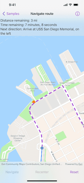
Tap "Navigate" to simulate traveling and to receive directions from a preset starting point to a preset destination. Tap "Reset" to start the simulation from the beginning.
How it works
- Create an
RouteTaskusing a URL to an online route service. - Generate default
RouteParametersusingRouteTask.makeDefaultParameters(). - Set
returnsRoutes,returnsStops, andreturnsDirectionson the parameters totrue. - Assign all
Stopobjects to the route parameters usingRouteParameters.setStops(_:). - Solve the route using
RouteTask.solveRoute(using:)to get aRouteResult. - Create an
RouteTrackerusing the route result, and the index of the desired route to take. - Create a
RouteTrackerLocationDataSourcewith the route tracker and aSimulatedLocationDataSourceobject to snap the location display to the route. - Use
RouteTracker.trackingStatusto be notified ofTrackingStatuschanges, and use them to display updated route information.TrackingStatusincludes a variety of information on the route progress, such as the remaining distance, remaining geometry or traversed geometry (represented by anPolyline), or the remaining time (TimeInterval), amongst others. - Use
RouteTracker.voiceGuidancesto be notified of new voice guidances. From the voice guidance, get theVoiceGuidance.textrepresenting the directions and use a text-to-speech engine to output the maneuver directions. - You can also query the tracking status for the current
DirectionManeuverindex, retrieve that maneuver from theRoute, and get its direction text to display in the GUI. - To establish whether the destination has been reached, get the
destinationStatusfrom the tracking status. If the destination status isreachedand theremainingDestinationCountis 1, you have arrived at the destination and can stop routing. If there are several destinations on your route and the remaining destination count is greater than 1, switch the route tracker to the next destination.
Relevant API
- DestinationStatus
- DirectionManeuver
- Location
- LocationDataSource
- Route
- RouteParameters
- RouteTask
- RouteTracker
- RouteTrackerLocationDataSource
- SimulatedLocationDataSource
- Stop
- VoiceGuidance
About the data
The route taken in this sample goes from the San Diego Convention Center, site of the annual Esri User Conference, to the Fleet Science Center, San Diego.
Tags
directions, maneuver, navigation, route, turn-by-turn, voice
Sample Code
NavigateRouteView.swift
// Copyright 2023 Esri // // Licensed under the Apache License, Version 2.0 (the "License"); // you may not use this file except in compliance with the License. // You may obtain a copy of the License at // // https://www.apache.org/licenses/LICENSE-2.0 // // Unless required by applicable law or agreed to in writing, software // distributed under the License is distributed on an "AS IS" BASIS, // WITHOUT WARRANTIES OR CONDITIONS OF ANY KIND, either express or implied. // See the License for the specific language governing permissions and // limitations under the License. import ArcGIS import AVFAudio import SwiftUI struct NavigateRouteView: View { /// The view model for this sample. @StateObject private var model = Model() var body: some View { MapView( map: model.map, viewpoint: model.viewpoint, graphicsOverlays: model.graphicsOverlays ) .onViewpointChanged(kind: .centerAndScale) { model.viewpoint = $0 } .locationDisplay(model.locationDisplay) .errorAlert(presentingError: $model.error) .overlay(alignment: .top) { Text(model.statusText) .frame(maxWidth: .infinity, alignment: .leading) .padding(8) .background(.thinMaterial, ignoresSafeAreaEdges: .horizontal) } .task { // Solves the route and sets the navigation. await model.solveRoute() model.setNavigation() } .toolbar { ToolbarItemGroup(placement: .bottomBar) { Button("Navigate") { model.isNavigatingRoute = true } .task(id: model.isNavigatingRoute) { guard model.isNavigatingRoute else { return } await model.startNavigation() } .disabled(model.isNavigateDisabled || model.isNavigatingRoute) Spacer() Button("Recenter") { model.autoPanMode = .navigation } .disabled(!model.isNavigatingRoute || model.autoPanMode == .navigation) Spacer() Button("Reset") { Task { await model.resetNavigation() model.isNavigatingRoute = false } } .disabled(model.isResettingRoute) } } } } private extension NavigateRouteView { /// A view model for this sample. @MainActor class Model: ObservableObject { /// A Boolean value indicating whether the navigate button is disabled. @Published var isNavigateDisabled = true /// A Boolean value indicating whether the sample is navigating the route. @Published var isNavigatingRoute = false /// A Boolean value indicating whether navigation is being reset. @Published var isResettingRoute = false /// The error shown in the error alert. @Published var error: Error? /// The viewpoint of the map. @Published var viewpoint: Viewpoint? /// The current auto-pan mode. @Published var autoPanMode: LocationDisplay.AutoPanMode { didSet { locationDisplay.autoPanMode = autoPanMode } } /// The status text to display to the user. @Published var statusText: String = defaultStatus /// A map with a navigation basemap style. let map = Map(basemapStyle: .arcGISNavigation) /// The map's location display. let locationDisplay = LocationDisplay() /// The default status to display when not navigating. static let defaultStatus = "Directions are shown here." /// The route task. private let routeTask = RouteTask(url: .routeTask) /// The route result. private var routeResult: RouteResult? /// The route tracker. private var routeTracker: RouteTracker! /// The directions for the route. private var directions: [DirectionManeuver] = [] /// An AVSpeechSynthesizer for text to speech. private let speechSynthesizer = AVSpeechSynthesizer() /// The graphics overlay for the stops. private let stopGraphicsOverlay: GraphicsOverlay /// The graphics overlay for the route. private let routeGraphicsOverlay: GraphicsOverlay /// Formats the time remaining for display. private let timeFormatter: DateComponentsFormatter = { let formatter = DateComponentsFormatter() formatter.allowedUnits = [.hour, .minute, .second] formatter.unitsStyle = .full return formatter }() /// The map's graphics overlays. var graphicsOverlays: [GraphicsOverlay] { return [stopGraphicsOverlay, routeGraphicsOverlay] } /// A graphic of the route remaining. private let routeRemainingGraphic: Graphic /// A graphic of the route traversed. private let routeTraversedGraphic: Graphic init() { autoPanMode = .off // Creates the graphics for each stop. let stopGraphics = Self.stops.map { Graphic( geometry: $0.geometry, symbol: SimpleMarkerSymbol(style: .diamond, color: .orange, size: 20) ) } // Creates the graphics for the route remaining and traversed. routeRemainingGraphic = Graphic(symbol: SimpleLineSymbol(style: .dash, color: .systemPurple, width: 5)) routeTraversedGraphic = Graphic(symbol: SimpleLineSymbol(style: .solid, color: .systemBlue, width: 3)) // Creates the graphics overlay for the stops and route. stopGraphicsOverlay = GraphicsOverlay(graphics: stopGraphics) routeGraphicsOverlay = GraphicsOverlay(graphics: [routeRemainingGraphic, routeTraversedGraphic]) } /// Solves the route. func solveRoute() async { do { // Creates the default parameters from the route task. let parameters = try await routeTask.makeDefaultParameters() // Configures the parameters. parameters.returnsDirections = true parameters.returnsStops = true parameters.returnsRoutes = true parameters.outputSpatialReference = .wgs84 // Sets the stops on the parameters. parameters.setStops(Self.stops) // Solves the route based on the parameters. routeResult = try await routeTask.solveRoute(using: parameters) // Enables the navigate button. isNavigateDisabled = false } catch { self.error = error } } /// Sets the route tracker and location display's data source with a solved route. Updates /// the list of directions, the route ahead graphic, and the map's viewpoint. func setNavigation() { guard let routeResult else { return } // Creates a route tracker from the route results. routeTracker = RouteTracker(routeResult: routeResult, routeIndex: 0, skipsCoincidentStops: true) guard let routeTracker else { return } routeTracker.voiceGuidanceUnitSystem = Locale.current.measurementSystem == .us ? .imperial : .metric // Gets the route and its geometry from the route result. guard let firstRoute = routeResult.routes.first, let routeGeometry = firstRoute.geometry else { return } // Updates the directions. directions = firstRoute.directionManeuvers // Creates the mock data source from the route's geometry. let densifiedRoute = GeometryEngine.geodeticDensify( routeGeometry, maxSegmentLength: 50, lengthUnit: .meters, curveType: .geodesic ) as! Polyline let mockDataSource = SimulatedLocationDataSource(polyline: densifiedRoute) // Creates a route tracker location data source. let routeTrackerLocationDataSource = RouteTrackerLocationDataSource( routeTracker: routeTracker, locationDataSource: mockDataSource ) // Sets the location display's data source. locationDisplay.dataSource = routeTrackerLocationDataSource // Updates the graphics and viewpoint. routeRemainingGraphic.geometry = routeGeometry viewpoint = Viewpoint(boundingGeometry: routeGeometry, rotation: 0) } /// Starts monitoring multiple asynchronous streams of information. private func startTracking() async { await withTaskGroup(of: Void.self) { group in group.addTask { await self.trackAutoPanMode() } group.addTask { await self.trackStatus() } group.addTask { await self.trackVoiceGuidance() } } } /// Monitors the asynchronous stream of tracking statuses. /// /// When new statuses are delivered, update the route's traversed and remaining graphics. private func trackStatus() async { for await status in routeTracker.$trackingStatus { if let status { routeTraversedGraphic.geometry = status.routeProgress.traversedGeometry routeRemainingGraphic.geometry = status.routeProgress.remainingGeometry switch status.destinationStatus { case .notReached, .approaching: statusText = """ Distance remaining: \(status.routeProgress.remainingDistance.distanceRemainingText) Time remaining: \(timeFormatter.string(from: status.routeProgress.remainingTime)!) """ if status.currentManeuverIndex + 1 < directions.count { statusText.append("\nNext direction: \(directions[status.currentManeuverIndex + 1].text)") } case .reached: if status.remainingDestinationCount > 1 { statusText = "Intermediate stop reached, continue to next stop." try? await routeTracker.switchToNextDestination() } else { await locationDisplay.dataSource.stop() } @unknown default: break } } } } /// Monitors the asynchronous stream of voice guidances. private func trackVoiceGuidance() async { for await voiceGuidance in routeTracker.voiceGuidances { speechSynthesizer.stopSpeaking(at: .word) speechSynthesizer.speak(AVSpeechUtterance(string: voiceGuidance.text)) } } /// Monitors the asynchronous stream of auto-pan modes. /// /// Updates the current auto-pan mode if it does not match the location display's auto-pan /// mode. private func trackAutoPanMode() async { for await mode in locationDisplay.$autoPanMode { if autoPanMode != mode { autoPanMode = mode } } } /// Starts navigating the route. func startNavigation() async { do { try await locationDisplay.dataSource.start() locationDisplay.autoPanMode = .navigation await startTracking() } catch { self.error = error } } /// Resets relevant stateful properties. func resetNavigation() async { guard !isResettingRoute else { return } isResettingRoute = true locationDisplay.autoPanMode = .off await locationDisplay.dataSource.stop() setNavigation() routeTraversedGraphic.geometry = nil speechSynthesizer.stopSpeaking(at: .immediate) statusText = Self.defaultStatus isResettingRoute = false } } } private extension NavigateRouteView.Model { /// The stops for this sample. static var stops: [Stop] { let one = Stop(point: Point(x: -117.160386727, y: 32.706608, spatialReference: .wgs84)) one.name = "San Diego Convention Center" let two = Stop(point: Point(x: -117.173034, y: 32.712329, spatialReference: .wgs84)) two.name = "USS San Diego Memorial" let three = Stop(point: Point(x: -117.147230, y: 32.730467, spatialReference: .wgs84)) three.name = "RH Fleet Aerospace Museum" return [one, two, three] } } private extension TrackingDistance { var distanceRemainingText: String { "\(displayText) \(self.displayTextUnits.abbreviation)" } } private extension URL { /// The URL for the route task. static var routeTask: URL { URL(string: "http://sampleserver7.arcgisonline.com/server/rest/services/NetworkAnalysis/SanDiego/NAServer/Route")! } } #Preview { NavigationStack { NavigateRouteView() } }