List features related to a selected feature.
Use case
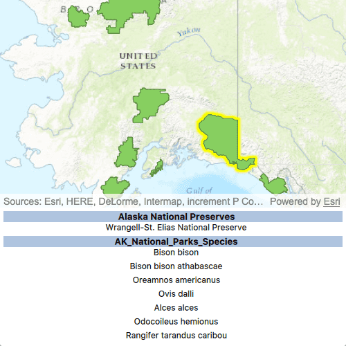
Related features are useful for managing relational information, like what you would store in a relational database management system (RDBMS). You can define relationship between records as one-to-one, one-to-many, or many-to-one. For example, you could model inspections and facilities as a many-to-one relationship. Then, for any facility feature, you could list related inspection features.
How to use the sample
Click on a feature to select it. The related features will be displayed in a list.
How it works
- With a
Feature, callqueryRelatedFeaturesAsyncon the feature's feature table. - Iterate over the result's collection of
RelatedFeatureQueryResultobjects to get the related features and add them to a list.
Relevant API
- ArcGISFeature
- ArcGISFeatureTable
- FeatureQueryResult
- ArcGISFeatureTable::queryRelatedFeaturesAsync
- RelatedFeatureQueryResult
Tags
features, identify, query, related, relationship, search
Sample Code
// [WriteFile Name=ListRelatedFeatures, Category=Features] // [Legal] // Copyright 2017 Esri. // // Licensed under the Apache License, Version 2.0 (the "License"); // you may not use this file except in compliance with the License. // You may obtain a copy of the License at // http://www.apache.org/licenses/LICENSE-2.0 // // Unless required by applicable law or agreed to in writing, software // distributed under the License is distributed on an "AS IS" BASIS, // WITHOUT WARRANTIES OR CONDITIONS OF ANY KIND, either express or implied. // See the License for the specific language governing permissions and // limitations under the License. // [Legal] #ifdef PCH_BUILD #include "pch.hpp" #endif // PCH_BUILD // sample headers #include "ListRelatedFeatures.h" #include "RelatedFeature.h" #include "RelatedFeatureListModel.h" // ArcGIS Maps SDK headers #include "ArcGISFeature.h" #include "ArcGISFeatureLayerInfo.h" #include "ArcGISFeatureTable.h" #include "AttributeListModel.h" #include "CoreTypes.h" #include "Envelope.h" #include "Error.h" #include "FeatureIterator.h" #include "FeatureLayer.h" #include "FeatureQueryResult.h" #include "LayerListModel.h" #include "Map.h" #include "MapQuickView.h" #include "MapTypes.h" #include "Point.h" #include "QueryParameters.h" #include "RelatedFeatureQueryResult.h" #include "SelectionProperties.h" #include "SpatialReference.h" #include "ViewInsets.h" // Qt headers #include <QFuture> #include <QList> #include <QUrl> #include <QUuid> // STL headers #include <memory> using namespace Esri::ArcGISRuntime; namespace { // Convenience RAII struct that deletes all pointers in given container. struct FeatureQueryListResultLock { FeatureQueryListResultLock(const QList<RelatedFeatureQueryResult*>& list) : results(list) { } ~FeatureQueryListResultLock() { qDeleteAll(results); } const QList<RelatedFeatureQueryResult*>& results; }; } ListRelatedFeatures::ListRelatedFeatures(QQuickItem* parent /* = nullptr */): QQuickItem(parent) { } void ListRelatedFeatures::init() { // Register the map view for QML qmlRegisterType<MapQuickView>("Esri.Samples", 1, 0, "MapView"); qmlRegisterType<ListRelatedFeatures>("Esri.Samples", 1, 0, "ListRelatedFeaturesSample"); qmlRegisterAnonymousType<ViewInsets>("Esri.Samples", 1); qmlRegisterUncreatableType<RelatedFeatureListModel>("Esri.ArcGISRuntimeSamples", 1, 0, "RelatedFeatureListModel", "RelatedFeatureListModel is an uncreatable type"); } void ListRelatedFeatures::componentComplete() { QQuickItem::componentComplete(); // Create a list model to store the related features m_relatedFeaturesModel = new RelatedFeatureListModel(this); emit relatedFeaturesModelChanged(); // find QML MapView component m_mapView = findChild<MapQuickView*>("mapView"); m_mapView->setSelectionProperties(SelectionProperties(QColor(Qt::yellow))); // Create a map using the URL of a web map m_map = new Map(QUrl("https://arcgis.com/home/item.html?id=dcc7466a91294c0ab8f7a094430ab437"), this); // Set map to map view m_mapView->setMap(m_map); // connect signals connectSignals(); } void ListRelatedFeatures::connectSignals() { // connect to doneLoading signal connect(m_map, &Map::doneLoading, this, [this](const Error& loadError) { if (!loadError.isEmpty()) return; bool foundLayer = false; // Found the Alaska National Parks layer. for (int i = 0; i < m_map->operationalLayers()->size() || !foundLayer; ++i) { // get the Alaska National Parks layer if (m_map->operationalLayers()->at(i)->name().contains(QStringLiteral("- Alaska National Parks"))) { foundLayer = true; m_alaskaNationalParks = static_cast<FeatureLayer*>(m_map->operationalLayers()->at(i)); m_alaskaFeatureTable = static_cast<ArcGISFeatureTable*>(m_alaskaNationalParks->featureTable()); } } }); // connect to the mouseClicked signal connect(m_mapView, &MapQuickView::mouseClicked, this, [this](QMouseEvent& mouseEvent) { // hide the attribute view emit hideAttributeTable(); // clear the list model m_relatedFeaturesModel->clear(); // create objects required to do a selection with a query Point clickPoint = m_mapView->screenToLocation(mouseEvent.position().x(), mouseEvent.position().y()); double mapTolerance = 10 * m_mapView->unitsPerDIP(); Envelope envelope = Envelope(clickPoint.x() - mapTolerance, clickPoint.y() - mapTolerance, clickPoint.x() + mapTolerance, clickPoint.y() + mapTolerance, m_map->spatialReference()); QueryParameters queryParams; queryParams.setGeometry(envelope); queryParams.setSpatialRelationship(SpatialRelationship::Intersects); // clear any selections m_alaskaNationalParks->clearSelection(); // select features m_alaskaNationalParks->selectFeaturesAsync(queryParams, SelectionMode::New).then(this, [this](FeatureQueryResult* rawResult) { auto result = std::unique_ptr<FeatureQueryResult>(rawResult); // The result could contain more than 1 feature, but we assume that // there is only ever 1. If more are given they are ignored. We // are only interested in the first (and only) feature. if (result->iterator().hasNext()) { m_selectedFeature = static_cast<ArcGISFeature*>(result->iterator().next(this)); // zoom to the selected feature m_mapView->setViewpointGeometryAsync(m_selectedFeature->geometry().extent(), 100); // query related features m_alaskaFeatureTable->queryRelatedFeaturesAsync(m_selectedFeature).then(this, [this](QList<RelatedFeatureQueryResult*> rawRelatedResults) { FeatureQueryListResultLock lock(rawRelatedResults); for (const RelatedFeatureQueryResult* relatedResult : lock.results) { while (relatedResult->iterator().hasNext()) { // get the related feature const ArcGISFeature* feature = static_cast<ArcGISFeature*>(relatedResult->iterator().next()); const ArcGISFeatureTable* relatedTable = static_cast<ArcGISFeatureTable*>(feature->featureTable()); const QString displayFieldName = relatedTable->layerInfo().displayFieldName(); const QString serviceLayerName = relatedTable->layerInfo().serviceLayerName(); const QString displayFieldValue = feature->attributes()->attributeValue(displayFieldName).toString(); // add the related feature to the list model RelatedFeature relatedFeature = RelatedFeature(displayFieldName, displayFieldValue, serviceLayerName); m_relatedFeaturesModel->addRelatedFeature(relatedFeature); emit relatedFeaturesModelChanged(); } } if (m_selectedFeature) { delete m_selectedFeature; m_selectedFeature = nullptr; } emit showAttributeTable(); }); } }); }); } QAbstractListModel* ListRelatedFeatures::relatedFeaturesModel() const { return m_relatedFeaturesModel; }