Use a stretch renderer to enhance the visual contrast of raster data for analysis.
Use case
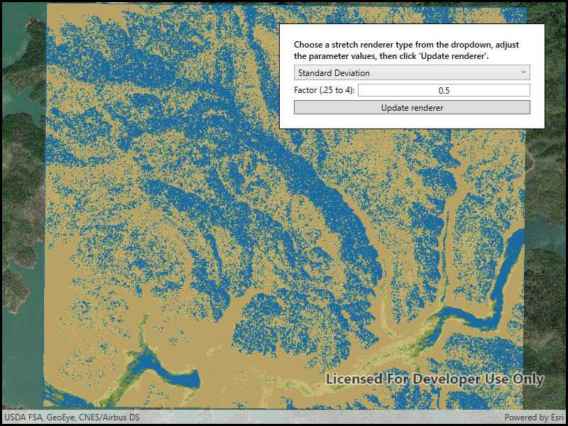
An appropriate stretch renderer can enhance the contrast of raster imagery, allowing the user to control how their data is displayed for efficient imagery analysis.
How to use the sample
Choose one of the stretch parameter types:
- Standard deviation - a linear stretch defined by the standard deviation of the pixel values
- Min-max - a linear stretch based on minimum and maximum pixel values
- Percent clip - a linear stretch between the defined percent clip minimum and percent clip maximum pixel values
Then configure the parameters and click 'Update renderer'.
How it works
- Create a
Rasterfrom a raster file. - Create a
RasterLayerfrom theRaster. - Add the layer to the map.
- Create a
StretchRenderer, specifying the stretch parameters and other properties. - Apply the
Rendererto the raster layer.
Relevant API
- ColorRamp
- MinMaxStretchParameters
- PercentClipStretchParameters
- Raster
- RasterLayer
- StandardDeviationStretchParameters
- StretchParameters
- StretchRenderer
Offline data
This sample downloads the following items from ArcGIS Online automatically:
- raster-file.zip - Tif raster file
About the data
This sample uses a raster imagery tile of an area of forested mountainous terrain and rivers.
Additional information
See Stretch function in the ArcMap documentation for more information about the types of stretches that can be performed.
Tags
analysis, deviation, histogram, imagery, interpretation, min-max, percent clip, pixel, raster, stretch, symbology, visualization
Sample Code
// Copyright 2018 Esri. // // Licensed under the Apache License, Version 2.0 (the "License"); you may not use this file except in compliance with the License. // You may obtain a copy of the License at: http://www.apache.org/licenses/LICENSE-2.0 // // Unless required by applicable law or agreed to in writing, software distributed under the License is distributed on an // "AS IS" BASIS, WITHOUT WARRANTIES OR CONDITIONS OF ANY KIND, either express or implied. See the License for the specific // language governing permissions and limitations under the License. using ArcGIS.Samples.Managers; using Esri.ArcGISRuntime.Mapping; using Esri.ArcGISRuntime.Rasters; using System; using System.Collections.Generic; using System.Threading.Tasks; using System.Windows; namespace ArcGIS.WPF.Samples.ChangeStretchRenderer { [ArcGIS.Samples.Shared.Attributes.Sample( name: "Stretch renderer", category: "Layers", description: "Use a stretch renderer to enhance the visual contrast of raster data for analysis.", instructions: "Choose one of the stretch parameter types:", tags: new[] { "analysis", "deviation", "histogram", "imagery", "interpretation", "min-max", "percent clip", "pixel", "raster", "stretch", "symbology", "visualization" })] [ArcGIS.Samples.Shared.Attributes.OfflineData("95392f99970d4a71bd25951beb34a508")] public partial class ChangeStretchRenderer { public ChangeStretchRenderer() { InitializeComponent(); // Create the UI, setup the control references and execute initialization _ = Initialize(); } private async Task Initialize() { // Initialize the GUI controls appearance RendererTypes.Items.Add("Min Max"); RendererTypes.Items.Add("Percent Clip"); RendererTypes.Items.Add("Standard Deviation"); RendererTypes.SelectedIndex = 0; // Add an imagery basemap MyMapView.Map = new Map(BasemapStyle.ArcGISImageryStandard); // Get the file name string filepath = GetRasterPath(); // Load the raster file Raster myRasterFile = new Raster(filepath); // Create the layer RasterLayer myRasterLayer = new RasterLayer(myRasterFile); // Add the layer to the map MyMapView.Map.OperationalLayers.Add(myRasterLayer); try { // Wait for the layer to load await myRasterLayer.LoadAsync(); // Set the viewpoint await MyMapView.SetViewpointGeometryAsync(myRasterLayer.FullExtent); } catch (Exception e) { MessageBox.Show(e.ToString(), "Error"); } } private void OnUpdateRendererClicked(object sender, RoutedEventArgs e) { // Convert the text to doubles and return if they're invalid. double input1; double input2; try { input1 = Convert.ToDouble(FirstParameterInput.Text); input2 = Convert.ToDouble(SecondParameterInput.Text); } catch (Exception ex) { MessageBox.Show(ex.Message); return; } // Get the user choice for the raster stretch render string myRendererTypeChoice = RendererTypes.SelectedValue.ToString(); // Create an IEnumerable from an empty list of doubles for the gamma values in the stretch render IEnumerable<double> myGammaValues = new List<double>(); // Create a color ramp for the stretch renderer ColorRamp myColorRamp = ColorRamp.Create(PresetColorRampType.DemLight, 1000); // Create the place holder for the stretch renderer StretchRenderer myStretchRenderer = null; switch (myRendererTypeChoice) { case "Min Max": // This section creates a stretch renderer based on a MinMaxStretchParameters // TODO: Add you own logic to ensure that accurate min/max stretch values are used // Create an IEnumerable from a list of double min stretch value doubles IEnumerable<double> myMinValues = new List<double> { input1 }; // Create an IEnumerable from a list of double max stretch value doubles IEnumerable<double> myMaxValues = new List<double> { input2 }; // Create a new MinMaxStretchParameters based on the user choice for min and max stretch values MinMaxStretchParameters myMinMaxStretchParameters = new MinMaxStretchParameters(myMinValues, myMaxValues); // Create the stretch renderer based on the user defined min/max stretch values, empty gamma values, statistic estimates, and a predefined color ramp myStretchRenderer = new StretchRenderer(myMinMaxStretchParameters, myGammaValues, true, myColorRamp); break; case "Percent Clip": // This section creates a stretch renderer based on a PercentClipStretchParameters // TODO: Add you own logic to ensure that accurate min/max percent clip values are used // Create a new PercentClipStretchParameters based on the user choice for min and max percent clip values PercentClipStretchParameters myPercentClipStretchParameters = new PercentClipStretchParameters(input1, input2); // Create the percent clip renderer based on the user defined min/max percent clip values, empty gamma values, statistic estimates, and a predefined color ramp myStretchRenderer = new StretchRenderer(myPercentClipStretchParameters, myGammaValues, true, myColorRamp); break; case "Standard Deviation": // This section creates a stretch renderer based on a StandardDeviationStretchParameters // TODO: Add you own logic to ensure that an accurate standard deviation value is used // Create a new StandardDeviationStretchParameters based on the user choice for standard deviation value StandardDeviationStretchParameters myStandardDeviationStretchParameters = new StandardDeviationStretchParameters(input1); // Create the standard deviation renderer based on the user defined standard deviation value, empty gamma values, statistic estimates, and a predefined color ramp myStretchRenderer = new StretchRenderer(myStandardDeviationStretchParameters, myGammaValues, true, myColorRamp); break; } // Get the existing raster layer in the map RasterLayer myRasterLayer = (RasterLayer)MyMapView.Map.OperationalLayers[0]; // Apply the stretch renderer to the raster layer myRasterLayer.Renderer = myStretchRenderer; } private void RendererTypes_SelectionChanged(object sender, System.Windows.Controls.SelectionChangedEventArgs e) { // Get the user choice for the raster stretch render string myRendererTypeChoice = e.AddedItems[0].ToString(); switch (myRendererTypeChoice) { case "Min Max": // This section displays/resets the user choice options for MinMaxStretchParameters // Make sure all the GUI items are visible FirstParameterLabel.Visibility = Visibility.Visible; SecondParameterLabel.Visibility = Visibility.Visible; FirstParameterInput.Visibility = Visibility.Visible; SecondParameterInput.Visibility = Visibility.Visible; // Define what values/options the user sees FirstParameterLabel.Text = "Minimum value (0 - 255):"; SecondParameterLabel.Text = "Maximum value (0 - 255):"; FirstParameterInput.Text = "10"; SecondParameterInput.Text = "150"; break; case "Percent Clip": // This section displays/resets the user choice options for PercentClipStretchParameters // Make sure all the GUI items are visible FirstParameterLabel.Visibility = Visibility.Visible; SecondParameterLabel.Visibility = Visibility.Visible; FirstParameterInput.Visibility = Visibility.Visible; SecondParameterInput.Visibility = Visibility.Visible; // Define what values/options the user sees FirstParameterLabel.Text = "Minimum (0 - 100):"; SecondParameterLabel.Text = "Maximum (0 - 100)"; FirstParameterInput.Text = "0"; SecondParameterInput.Text = "50"; break; case "Standard Deviation": // This section displays/resets the user choice options for StandardDeviationStretchParameters // Make sure that only the necessary GUI items are visible FirstParameterLabel.Visibility = Visibility.Visible; SecondParameterLabel.Visibility = Visibility.Collapsed; FirstParameterInput.Visibility = Visibility.Visible; SecondParameterInput.Visibility = Visibility.Collapsed; // Define what values/options the user sees FirstParameterLabel.Text = "Factor (.25 to 4):"; FirstParameterInput.Text = "0.5"; break; } } private static string GetRasterPath() { return DataManager.GetDataFolder("95392f99970d4a71bd25951beb34a508", "shasta", "ShastaBW.tif"); } } }