Perform a viewshed analysis from a defined vantage point.
Use case
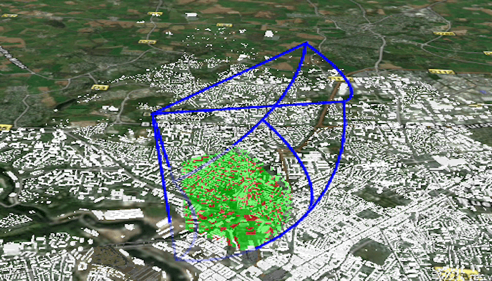
A 3D viewshed analysis is a type of visual analysis you can perform on a scene. The viewshed shows what can be seen from a given location. The output is an overlay with two different colors - one representing the visible areas (green) and the other representing the obstructed areas (red). Viewshed analysis is a form of "exploratory analysis", which means the results are calculated on the current scale of the data, and the results are generated very quickly. If more "conclusive" results are required, consider using a GeoprocessingTask to perform a viewshed instead.
How to use the sample
Use the sliders to change the properties (heading, pitch, etc.), of the viewshed and see them updated in real time.
How it works
- Create a
LocationViewshedpassing in the observer location, heading, pitch, horizontal/vertical angles, and min/max distances. - Set the property values on the viewshed instance for location, direction, range, and visibility properties.
Relevant API
- AnalysisOverlay
- ArcGISSceneLayer
- ArcGISTiledElevationSource
- LocationViewshed
- Viewshed
About the data
The scene shows a buildings layer in Brest, France hosted on ArcGIS Online.
Additional information
This sample uses the GeoView-Compose Toolkit module to be able to implement a composable SceneView.
Tags
3D, frustum, geoview-compose, scene, viewshed, visibility analysis
Sample Code
/* Copyright 2023 Esri * * Licensed under the Apache License, Version 2.0 (the "License"); * you may not use this file except in compliance with the License. * You may obtain a copy of the License at * * http://www.apache.org/licenses/LICENSE-2.0 * * Unless required by applicable law or agreed to in writing, software * distributed under the License is distributed on an "AS IS" BASIS, * WITHOUT WARRANTIES OR CONDITIONS OF ANY KIND, either express or implied. * See the License for the specific language governing permissions and * limitations under the License. * */ package com.esri.arcgismaps.sample.showviewshedfrompointinscene.components import android.app.Application import androidx.compose.runtime.getValue import androidx.compose.runtime.mutableStateOf import androidx.compose.runtime.setValue import androidx.lifecycle.AndroidViewModel import com.arcgismaps.analysis.LocationViewshed import com.arcgismaps.geometry.Point import com.arcgismaps.mapping.ArcGISScene import com.arcgismaps.mapping.ArcGISTiledElevationSource import com.arcgismaps.mapping.BasemapStyle import com.arcgismaps.mapping.Surface import com.arcgismaps.mapping.Viewpoint import com.arcgismaps.mapping.layers.ArcGISSceneLayer import com.arcgismaps.mapping.view.AnalysisOverlay import com.arcgismaps.mapping.view.Camera import com.arcgismaps.mapping.view.OrbitLocationCameraController import com.esri.arcgismaps.sample.showviewshedfrompointinscene.R class SceneViewModel(private val application: Application) : AndroidViewModel(application) { // initialize location viewshed parameters private var viewShed: LocationViewshed private val initHeading = 82.0 private val initPitch = 60.0 private val initHorizontalAngle = 75.0 private val initVerticalAngle = 90.0 private val initMinDistance = 0.0 private val initMaxDistance = 1500.0 private val initLocation = Point( x = -4.50, y = 48.4, z = 1000.0 ) private val camera = Camera( lookAtPoint = initLocation, distance = 20000000.0, heading = 0.0, pitch = 55.0, roll = 0.0 ) val cameraController = OrbitLocationCameraController( targetPoint = initLocation, distance = 5000.0 ) var scene by mutableStateOf(ArcGISScene(BasemapStyle.ArcGISNavigationNight)) var analysisOverlay by mutableStateOf(AnalysisOverlay()) init { // create a surface for elevation data val surface = Surface().apply { elevationSources.add(ArcGISTiledElevationSource(application.getString(R.string.elevation_service))) } // create a layer of buildings val buildingsSceneLayer = ArcGISSceneLayer(application.getString(R.string.buildings_layer)) // create a scene and add imagery basemap, elevation surface, and buildings layer to it val buildingsScene = ArcGISScene(BasemapStyle.ArcGISImagery).apply { baseSurface = surface operationalLayers.add(buildingsSceneLayer) } val initLocation = Point(-4.50, 48.4, 1000.0) // create viewshed from the initial location viewShed = LocationViewshed( location = initLocation, heading = initHeading, pitch = initPitch, horizontalAngle = initHorizontalAngle, verticalAngle = initVerticalAngle, minDistance = initMinDistance, maxDistance = initMaxDistance ).apply { frustumOutlineVisible = true } // add the buildings scene to the sceneView scene = buildingsScene.apply { baseSurface = surface initialViewpoint = Viewpoint(initLocation, camera) } // add the viewshed to the analysisOverlay of the scene view analysisOverlay.apply { analyses.add(viewShed) isVisible = true } } fun setHeading(sliderHeading: Float) { viewShed.heading = sliderHeading.toDouble() } fun setMaximumDistanceSlider(sliderValue: Float) { viewShed.maxDistance = sliderValue.toDouble() } fun setMinimumDistanceSlider(sliderValue: Float) { viewShed.minDistance = sliderValue.toDouble() } fun setVerticalAngleSlider(sliderValue: Float) { viewShed.verticalAngle = sliderValue.toDouble() } fun setHorizontalAngleSlider(sliderValue: Float) { viewShed.horizontalAngle = sliderValue.toDouble() } fun setPitch(sliderValue: Float) { viewShed.pitch = sliderValue.toDouble() } fun frustumVisibility(checkedValue: Boolean) { viewShed.frustumOutlineVisible = checkedValue } fun analysisVisibility(checkedValue: Boolean) { viewShed.isVisible = checkedValue } }