Edit feature attributes which are linked to annotation through an expression.
Use case
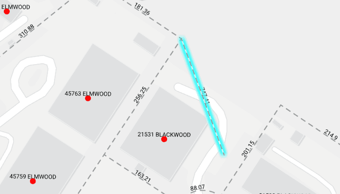
Annotation is useful for displaying text that you don't want to move or resize when the map is panned or zoomed (unlike labels which will move and resize). Feature-linked annotation will update when a feature attribute referenced by the annotation expression is also updated. Additionally, the position of the annotation will transform to match any transformation to the linked feature's geometry.
How to use the sample
Pan and zoom the map to see that the text on the map is annotation, not labels. Tap one of the address points to update the house number (AD_ADDRESS) and street name (ST_STR_NAM) and change its geometry. Tap one of the dashed parcel polylines and tap another location to change its geometry. Note: Selection is only enabled for points and straight (single segment) polylines.
The feature-linked annotation will update accordingly.
How it works
- Load the geodatabase. Note: Read/write geodatabases should normally come from a
GeodatabaseSyncTask, but this has been omitted here. - Create
FeatureLayers from geodatabase feature tables found in the geodatabase. - Create
AnnotationLayers from geodatabase annotation tables found in the geodatabase. - Add the
FeatureLayers andAnnotationLayers to the map's operational layers. - Use a map tap gesture to select address points or parcel polyline features. Note: Selection is only enabled for points and straight (single segment) polylines.
- For the address points, a dialog is opened to allow editing of the address number (
AD_ADDRESS) and street name (ST_STR_NAM) attributes. - For the parcel lines, a second tap will change one of the polyline's vertices.
- For the address points, a dialog is opened to allow editing of the address number (
Both expressions were defined by the data author in ArcGIS Pro using the Arcade expression language.
Relevant API
- AnnotationLayer
- Feature
- FeatureLayer
- Geodatabase
Offline data
This sample uses data from ArcGIS Online. It is downloaded automatically.
About the data
This sample uses data derived from the Loudoun GeoHub.
The annotation linked to the point data in this sample is defined by arcade expression $feature.AD_ADDRESS + " " + $feature.ST_STR_NAM. The annotation linked to the parcel polyline data is defined by Round(Length(Geometry($feature), 'feet'), 2).
Tags
annotation, attributes, feature-linked annotation, features, fields
Sample Code
/* Copyright 2025 Esri * * Licensed under the Apache License, Version 2.0 (the "License"); * you may not use this file except in compliance with the License. * You may obtain a copy of the License at * * http://www.apache.org/licenses/LICENSE-2.0 * * Unless required by applicable law or agreed to in writing, software * distributed under the License is distributed on an "AS IS" BASIS, * WITHOUT WARRANTIES OR CONDITIONS OF ANY KIND, either express or implied. * See the License for the specific language governing permissions and * limitations under the License. * */ package com.esri.arcgismaps.sample.editfeatureswithfeaturelinkedannotation.components import android.app.Application import androidx.compose.runtime.getValue import androidx.compose.runtime.mutableIntStateOf import androidx.compose.runtime.mutableStateOf import androidx.compose.runtime.setValue import androidx.compose.ui.unit.dp import androidx.lifecycle.AndroidViewModel import androidx.lifecycle.viewModelScope import com.arcgismaps.data.ArcGISFeature import com.arcgismaps.data.Geodatabase import com.arcgismaps.geometry.Geometry import com.arcgismaps.geometry.GeometryEngine import com.arcgismaps.geometry.Point import com.arcgismaps.geometry.Polyline import com.arcgismaps.geometry.PolylineBuilder import com.arcgismaps.geometry.SpatialReference import com.arcgismaps.mapping.ArcGISMap import com.arcgismaps.mapping.BasemapStyle import com.arcgismaps.mapping.Viewpoint import com.arcgismaps.mapping.layers.AnnotationLayer import com.arcgismaps.mapping.layers.FeatureLayer import com.arcgismaps.mapping.view.IdentifyLayerResult import com.arcgismaps.mapping.view.ScreenCoordinate import com.arcgismaps.toolkit.geoviewcompose.MapViewProxy import com.esri.arcgismaps.sample.editfeatureswithfeaturelinkedannotation.R import com.esri.arcgismaps.sample.sampleslib.components.MessageDialogViewModel import kotlinx.coroutines.Dispatchers import kotlinx.coroutines.flow.MutableStateFlow import kotlinx.coroutines.flow.asStateFlow import kotlinx.coroutines.launch import java.io.File class EditFeaturesWithFeatureLinkedAnnotationViewModel(app: Application) : AndroidViewModel(app) { // Path to the geodatabase in the app's external files dir private val provisionPath: String by lazy { app.getExternalFilesDir(null)?.path.toString() + File.separator + app.getString(R.string.edit_features_with_feature_linked_annotation_app_name) } // Geodatabase and layer names private val geodatabaseFileName = "loudoun_anno.geodatabase" private val addressPointsTableName = "Loudoun_Address_Points_1" private val addressAnnoTableName = "Loudoun_Address_PointsAnno_1" private val parcelLinesTableName = "ParcelLines_1" private val parcelAnnoTableName = "ParcelLinesAnno_1" private val addressNumberAttribute = "AD_ADDRESS" private val streetNameAttribute = "ST_STR_NAM" // Map centered on Loudoun County, VA var arcGISMap = ArcGISMap(BasemapStyle.ArcGISLightGray).apply { initialViewpoint = Viewpoint(39.0204, -77.4159, 2256.0) } // Proxy for identify operations with the map view val mapViewProxy = MapViewProxy() // ViewModel for showing messages val messageDialogVM = MessageDialogViewModel() // UI state private val _instruction = MutableStateFlow<Instruction>(Instruction.SelectFeature) val instruction = _instruction.asStateFlow() // Currently selected feature (point or polyline) var selectedFeature: ArcGISFeature? by mutableStateOf(null) private set // Flag to show/hide the edit address dialog var showEditAddressDialog: Boolean by mutableStateOf(false) private set // For editing address var buildingNumber: Int by mutableIntStateOf(0) private set var streetName: String by mutableStateOf("") private set // Geodatabase and layers private var loudonGeodatabase: Geodatabase? = null private var addressFeatureLayer: FeatureLayer? = null private var parcelFeatureLayer: FeatureLayer? = null init { viewModelScope.launch { loadGeodatabaseAndLayers() } } /** * Load the geodatabase and its feature/annotation layers. * If the geodatabase is not found, show an error message. */ private suspend fun loadGeodatabaseAndLayers() { // Check if the geodatabase file exists val gdbFile = File(provisionPath, geodatabaseFileName) if (!gdbFile.exists()) { messageDialogVM.showMessageDialog("Geodatabase not found", "Expected at: ${gdbFile.path}") return } // Create and load the geodatabase val geodatabase = Geodatabase(gdbFile.path) loudonGeodatabase = geodatabase geodatabase.load().onFailure { messageDialogVM.showMessageDialog(it) return } // Get feature tables from the geodatabase val addressTable = geodatabase.featureTables.find { it.tableName == addressPointsTableName } val parcelTable = geodatabase.featureTables.find { it.tableName == parcelLinesTableName } // Create feature layers from the tables addressFeatureLayer = addressTable?.let { FeatureLayer.createWithFeatureTable(it) } parcelFeatureLayer = parcelTable?.let { FeatureLayer.createWithFeatureTable(it) } // Get annotation tables from the geodatabase val addressAnnotationTable = geodatabase.annotationTables.find { it.tableName == addressAnnoTableName } val parcelAnnotationTable = geodatabase.annotationTables.find { it.tableName == parcelAnnoTableName } // Create annotation layers from the tables val addressAnnotationLayer = addressAnnotationTable?.let { AnnotationLayer(it) } val parcelAnnotationLayer = parcelAnnotationTable?.let { AnnotationLayer(it) } // Add layers to map arcGISMap.operationalLayers.clear() listOfNotNull(addressFeatureLayer, parcelFeatureLayer, addressAnnotationLayer, parcelAnnotationLayer).forEach { arcGISMap.operationalLayers.add(it) } } /** * Handle single tap on the map. * If a feature is already selected, treat as move confirmation. * Otherwise, identify the feature at the tapped location. */ fun onMapSingleTap(screenCoordinate: ScreenCoordinate, mapPoint: Point) { // If a feature is already selected, treat as move confirmation if (selectedFeature != null) { // Only allow move for point or straight polyline val feature = selectedFeature ?: return if (feature.geometry is Point || isStraightPolyline(feature.geometry)) { onMoveFeatureConfirmed(feature, mapPoint) } else { clearSelection() _instruction.value = Instruction.SelectFeature } return } // Otherwise, identify feature at tap viewModelScope.launch { val results = mapViewProxy.identifyLayers( screenCoordinate = screenCoordinate, tolerance = 10.dp, returnPopupsOnly = false, maximumResults = 1 ).getOrElse { messageDialogVM.showMessageDialog(it) return@launch } selectFirstFeature(results) } } /** * Select the first feature from the identify results. * If it's a point, show the edit address dialog. * If it's a straight polyline, allow moving it. * Otherwise, clear selection and show instruction to select a feature. */ private fun selectFirstFeature(results: List<IdentifyLayerResult>) { clearSelection() // Prefer feature layers only val featureLayerResult = results.firstOrNull { it.layerContent is FeatureLayer && it.geoElements.isNotEmpty() } ?: return val featureLayer = featureLayerResult.layerContent as? FeatureLayer ?: return val feature = featureLayerResult.geoElements.firstOrNull() as? ArcGISFeature ?: return featureLayer.selectFeature(feature) selectedFeature = feature when (feature.geometry) { is Point -> { showEditAddressDialog = true // Prepare address editing val adAddress = feature.attributes[addressNumberAttribute] as Int val stStrNam = feature.attributes[streetNameAttribute]?.toString() ?: "" buildingNumber = adAddress streetName = stStrNam selectedFeature = feature _instruction.value = Instruction.MoveFeature } is Polyline -> { if (isStraightPolyline(feature.geometry)) { _instruction.value = Instruction.MoveFeature } else { // Only allow straight polylines _instruction.value = Instruction.SelectStraightPolyline clearSelection() } } else -> { _instruction.value = Instruction.SelectFeature clearSelection() } } } /** * Handle confirmation of address editing. * Update the feature's attributes and keep it selected so that it can be moved. */ fun onEditAddressConfirmed(feature: ArcGISFeature?, newBuildingNumber: Int, newStreetName: String) { viewModelScope.launch { try { feature?.let { feature -> feature.attributes[addressNumberAttribute] = newBuildingNumber feature.attributes[streetNameAttribute] = newStreetName feature.featureTable?.updateFeature(feature)?.onFailure { error -> messageDialogVM.showMessageDialog(error) } // Keep the feature selected and update the instruction buildingNumber = newBuildingNumber streetName = newStreetName _instruction.value = Instruction.MoveFeature } // Close the dialog showEditAddressDialog = false } catch (e: Exception) { messageDialogVM.showMessageDialog(e) } } } fun onMoveFeatureConfirmed(feature: ArcGISFeature, mapPoint: Point) { viewModelScope.launch(Dispatchers.IO) { try { when (val geom = feature.geometry) { is Point -> { feature.geometry = mapPoint } is Polyline -> { // Move nearest vertex to tapPoint val polyline = geom val spatialRef = polyline.spatialReference ?: SpatialReference.wgs84() val projectedTap = GeometryEngine.projectOrNull(mapPoint, spatialRef) ?: mapPoint val nearestVertex = GeometryEngine.nearestVertex(polyline, projectedTap) if (nearestVertex != null) { val builder = PolylineBuilder(polyline) val partIdx = nearestVertex.partIndex val pointIdx = nearestVertex.pointIndex builder.parts[partIdx].setPoint(pointIdx, projectedTap) feature.geometry = builder.toGeometry() } } else -> { } } feature.featureTable?.updateFeature(feature)?.onFailure { messageDialogVM.showMessageDialog(it) } clearSelection() _instruction.value = Instruction.SelectFeature } catch (e: Exception) { messageDialogVM.showMessageDialog(e) } } } /** * Clear the selection and reset the selected feature. */ fun clearSelection() { selectedFeature?.let { feature -> val layer = arcGISMap.operationalLayers.filterIsInstance<FeatureLayer>().firstOrNull { it.featureTable == feature.featureTable } layer?.clearSelection() } selectedFeature = null buildingNumber = 0 streetName = "" } /** * Check if the geometry is a straight polyline (single-part, single-segment). * This is used to ensure only valid polylines can be moved. */ private fun isStraightPolyline(geometry: Geometry?): Boolean { val polyline = geometry as? Polyline ?: return false // Only allow single-part, single-segment polylines return polyline.parts.size == 1 && polyline.parts.first().points.toList().size == 2 } /** * Update the building number for address editing. */ fun onBuildingNumberChange(newBuildingNumber: Int) { buildingNumber = newBuildingNumber } /** * Update the street name for address editing. */ fun onStreetNameChange(newStreetName: String) { streetName = newStreetName } /** * Update the visibility of the edit address dialog. */ fun onShowEditAddressDialogChange(show: Boolean) { showEditAddressDialog = show } } /** * Instructions for the user based on the current state of the map interaction. * These are used to guide the user on what actions to take next. */ sealed class Instruction(val message: String) { data object SelectFeature : Instruction("Select a point or straight polyline to edit.") data object SelectStraightPolyline : Instruction("Select straight (single segment) polylines only.") data object MoveFeature : Instruction("Tap on the map to move the feature.") }